


NemoScoutApp app for iPhone and iPad
Developer: Stephan Edelman
First release : 30 Apr 2020
App size: 15.05 Mb
NemoScoutApp is a companion app to the NemoScout transponder (sold separately) -a matchbox sized portable WAAS GPS with built-in collision avoidance transponder and tracker- utilized by flight schools and individuals to improve situational awareness and pilot decision making. It enables flight schools to track the position of all NemoScout equipped aircraft in their fleet in real-time. Track logs are stored on SD card in standard G1000 format and can be used with debriefing tools such as CloudAhoy.
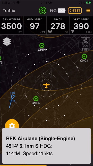
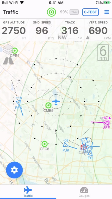
The app provides for a visual display of the traffic surrounding your present position using a TCAS-like display. Traffic is identified by triangles on top of a moving map that indicate the direction and altitude difference of any conflicting aircraft. Visual and audible warnings are provided when conflicting aircraft breach minimum clearance distances configured in the app. Different clearance distances for aircraft and obstacles can be applied when traveling en-route or when flying the pattern.
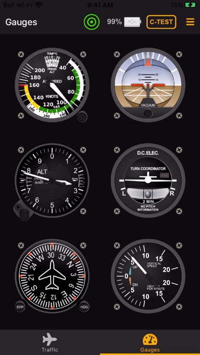
The app can also be utilized to display ground speed, altitude, heading, vertical speed, attitude and rate of turn for back up purposes to your main instruments. Ground speed, vertical speed and altitude are obtained from the integrated WAAS GPS. Heading and attitude are obtained from the integrated AHRS sensor.
The app includes an integrated airport database, obstacle database and airspace database that is updated every 56 days. The airport database (North America only) identifies all registered open-to-the-public aerodromes (grass or paved). Airports with weather available are identified in red and can be tapped to reveal the local METAR. Weather is received either over-the-air (for equipped aerodromes) or over the Internet (requires a 3G/4G/LTE connection). The obstacle database (North America only) contains most man-made obstacles taller than 200ft above the ground, including communication towers and windmills. The airspace database (North America only) identifies all control zones (CZ), terminal control areas (TCA), restricted CYA and CYR areas and all associated height restrictions.
The app can be utilized to send GDL90 compatible GPS position and traffic information to compatible EFB apps (operating on the same WiFi access point), including ForeFlight, WingX, FltPlan Go, FlyQ EFB, iFly GPS and others. Note that attitude information is displayed in most EFB apps, with the exception of ForeFlight.